Experts predicted more hurricanes in the Caribbean this summer – where are the ‘missing’ storms?

مجلة المذنب نت متابعات عالمية:
Back in April and May 2024, various universities and weather agencies predicted there would be more hurricanes in the Atlantic than usual this year. Warm seas meant conditions were perfect for a particularly active season, they said, with somewhere between 15 and 25 named storms.
Yet by mid-September, the typical peak of the hurricane season, only seven storms have been named. Where are the “missing” hurricanes in the Caribbean? To understand what happened, and why the models seemingly got it so wrong, we can’t look at the Atlantic in isolation. The key difference this year was unprecedented rain in an unexpected place: the Sahara desert.
The 2024 hurricane season kicked off with a bang: Hurricane Beryl, which made landfall on the island of Carriacou in Grenada on July 1, was the earliest category 5 storm on record. After Beryl, there was a quiet period: an outbreak of Saharan dust meant that the air over the tropical Atlantic was too dry to sustain the moist clouds needed to develop a hurricane. July is generally a less active part of the season, so this is not too unusual: only one storm was named in July between 2021 and 2023.
In early August, Beryl was followed by Hurricanes Debby and Ernesto, but between August 13 and September 3, there were no named storms in the Atlantic at all. That’s only happened once before on those dates, back in 1968.
In 2023, the hottest seas on record led to 20 named storms in the Atlantic, the fourth most active hurricane season on record. This year, the sea is just as hot, as predicted by the climate models. However, other factors that inhibited hurricane development were not anticipated as reliably.
From ‘waves’ in Africa, to Caribbean hurricanes
Between June and September, west Africa typically experiences a monsoon: wet air from the Gulf of Guinea travels northward, bringing rain and thunderstorms to the transitional region between the rainforests of central Africa and the Sahara – an area known as the Sahel. This creates a stark contrast in land temperatures between the wet, green Sahel, and the dry desert to its north, which in turn allows a high-altitude “atmospheric jet” to form.
TAGHLAOUIFOTOS / shutterstock
Smaller “waves” can spin off from this jet. We call them African easterly waves, since they originate in the east and move westward over Africa, and these are linked to large thunderstorms and low pressures. Strong easterly waves can move off the coast of Africa and create areas of low pressure and rotating air in the Atlantic, which can become hurricanes. It is estimated that around 60% of major Atlantic storms can be traced back to these waves.
The waves move northwards
This year, an exceptionally warm sea allowed moist air to travel further north over west Africa which brought unprecedented rainfall to the Sahara. Northern Chad has experienced weeks of torrential rain, for instance, while Morocco and Algeria have been hit by huge floods, with some areas receiving a year’s worth of rain in just two days.
Rainfall across Africa in early September 2024:
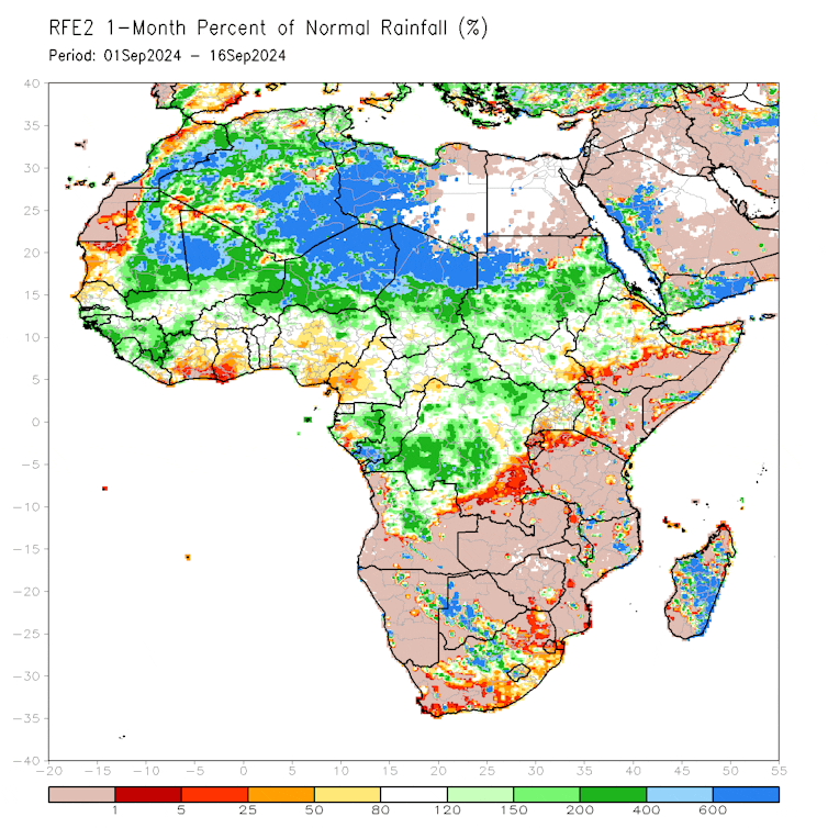
NOAA
With the moist monsoon air reaching further north than usual, easterly waves are emerging into the ocean via Mauritania or Western Sahara rather than Senegal or the Gambia. There, the ocean is cooler, and, as the waves rotate, they bring in cooler, drier air from the north, so there is not as much energy for waves to turn into storms.
Effectively, if these waves are the seeds of major storms then they have been planted in the wrong soil: unable to receive the warmth and moisture they need to develop into hurricanes.
Other factors have also been at play, including the Madden-Julian Oscillation, a global pattern of stormy weather which moves eastward around the globe. Over the past few months, the oscillation has been in a phase which does not favour tropical cyclone development. The upper atmosphere has also been too warm for storms to form, and the winds there are stronger than usual, causing some potential tropical cyclones to collapse.
State-of-the-art climate models suggest that in a warming climate, the west African monsoon may become wetter and shift further northwards, potentially resulting in similarly quiet hurricane seasons in future. However, future projections of rainfall in Africa can be somewhat uncertain, and more research could be essential not only to forecast extreme weather in the region itself, but also to understand changes downstream.
However, things may soon be back to normal as the monsoon retreats southward and the sea surface keeps heating up (ocean temperatures typically peak in October), providing the necessary moisture and heat. While the typical season for easterly waves is nearing its end, storms could continue to form from disturbances in the Caribbean. Researchers at Colorado State University, widely considered some of the most accurate hurricane forecasters, have estimated a 50% chance of a return to normal hurricane activity in the next two weeks.
While we have been fortunate to have a lull in storms in the 2024 season, it is not over yet. If tropical cyclones do develop, with such high sea surface temperatures, it is possible that they will intensify rapidly to become high-impact storms. Though it was months ago, Hurricane Beryl has been a reminder that even in a quiet season, hurricanes can still do catastrophic damage.
نشكركم على قراءة المنشور عبر مجلة المذنب نت, المتخصصة في التداول والعملات الرقمية والمشفرة


